Location Tools

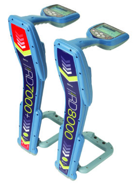
PRD7000+ & RD8000
+ LOCATION TOOLS
Radiodetection’s precision locators are designed for optimal locate performance for all industries and utilities. Common to all is the powerful Centros™ measurement engine, based on more than 30 years of development. Centros delivers a powerful digital signal analysis platform and provides the operator with a comprehensive suite of reliable and accurate information.
The Precision Locate range comprises the fully featured, multifunctional, RD8000™ locators and the utility-specific RD7000™+ range.

FEATURES
RD8000
The multifunctional RD8000 range represents Radiodetection’s most advanced pipe, cable, and RF marker locators, offering a wide choice of locate functions and advanced connectivity options. The RD8000 improves on speed, accuracy, and reliability yet remains a cost-effective solution delivering unique user features. Powered by a digital architecture, RD8000 delivers a highly controllable and reliable locate solution to service any industry.
RD7000+
Locating specific pipes, cables, and utility RF markers in large underground networks is very complex. Ground distortion effects, caused by differing soil types and proximity to other conductors, make the user’s job more difficult and time-consuming. The most important requirements for a locator under these circumstances are ease of use, accuracy, and reliability. Radiodetection’s RD7000+ Utility Locator range addresses these needs with many features that deliver accurate, reliable, and repeatable performance. The new RD7000+ marker locators – denoted ‘M’ add RF marker locating to the range, with automatic marker depth estimation and Bluetooth® connectivity as standard
- Identifies Power, Radio, and several Active Signals.
- Provides a Peak and Null indication, plus a Compass.
- Provides Depth and Current when used with a TX Transmitter.
Data Logging and Analysis
eC.A.T4 and gC.A.T4 models provide data acquisition capabilities, allowing Plant Supervisors to administer their fleet more safely and effectively by providing comprehensive logs of C.A.T4 usage for analysis and personnel development. gC.A.T4 models are equipped with a built-in GPS/GNSS receiver to show where the CATs were used. CSV, XLS or KML files can be easily exported to map services such as Google Earth.
(RD8000 can also provide advanced diagnostics).
- Available with folding foot, which when enabled allows for the location of RF Marker Balls.
- Several models/features
SPECIFICATION SHEETS
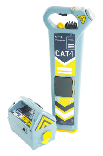
C.A.T4 & GENNY4
+ LOCATION TOOLS
The C.A.T4 digital platform delivers highly refined locate capabilities, location tools specifically designed to help the operator find more buried utilities.
The C.A.T4 Avoidance Mode™ lets the operator check an intended excavation area for Power, Radio and Genny signals, and pinpoint located utilities in a single scan. Features such as the bar graph ‘tidemark’ enable an operator to quickly spot a peak response and zero-in on a buried conductor. The Genny4 Signal Generator provides simultaneous dual-frequency locate signal output. Alongside the familiar 33kHz locate signal for general purpose locates, the Genny4 transmits a second higher frequency designed to facilitate location of small diameter cables such as telecoms and street lighting, including spurs.
For tricky locates, the power boost function enables the locate signal to travel further and deeper, and couple onto utilities more easily. Radiodetection’s proprietary StrikeAlert™ warning, warns of shallow buried utilities. The C.A.T4 guides users towards better and safer working practices through its SWING™ Rate detector and Service Due date warning. C.A.T4 is a safety-critical precision instrument and the optional 30-day countdown to the Service Due date, CALSafe™ and innovative eCert™ on-line system calibration validation capabilities are designed to reinforce company and recommended service policies

FEATURES
- Entry-level Location Tools – Simple to use with reliable results.
- Avoidance Mode.
- Genny signal locate.
- Identifies Power, Radio, and Active Signals.
- Small Diameter Locate frequency.
- Dynamic Overload Protection.
- Provides Depth when used with GENNY 33kHz signal.
- Online Calibration checking.
Widely utilised by Utilities, Councils, and Contractors that need to know where not to dig.
Data Logging and Analysis
C.A.T. models provide data acquisition capabilities, allowing Plant Supervisors to administer their fleet more safely and effectively by providing comprehensive logs of C.A.T4 usage for analysis and personnel development. gC.A.T4 models are equipped with a built-in GPS/GNSS receiver to show where the CATs were used. CSV, XLS, or KML files can be easily exported to map services such as Google Earth.
Reverse Compatibility
C.A.T4 and Genny4 are compatible with all C.A.T3 and Genny3 accessories.

